
Checkerboard Site Guide
Paragliding in the Flathead Valley
Last Updated 3/3/2026
Site Director: Flathead Valley Soaring Association Board of Directors
P3+/H3+ Unrestricted - P2/H2 with Restrictions/Conditions
Wind: Southwest (ideal is 200 to 220 degrees)
Wind Speeds: For Hang Gliding and Paragliding minimum 0, ideal 6 mph, maximum 8 mph

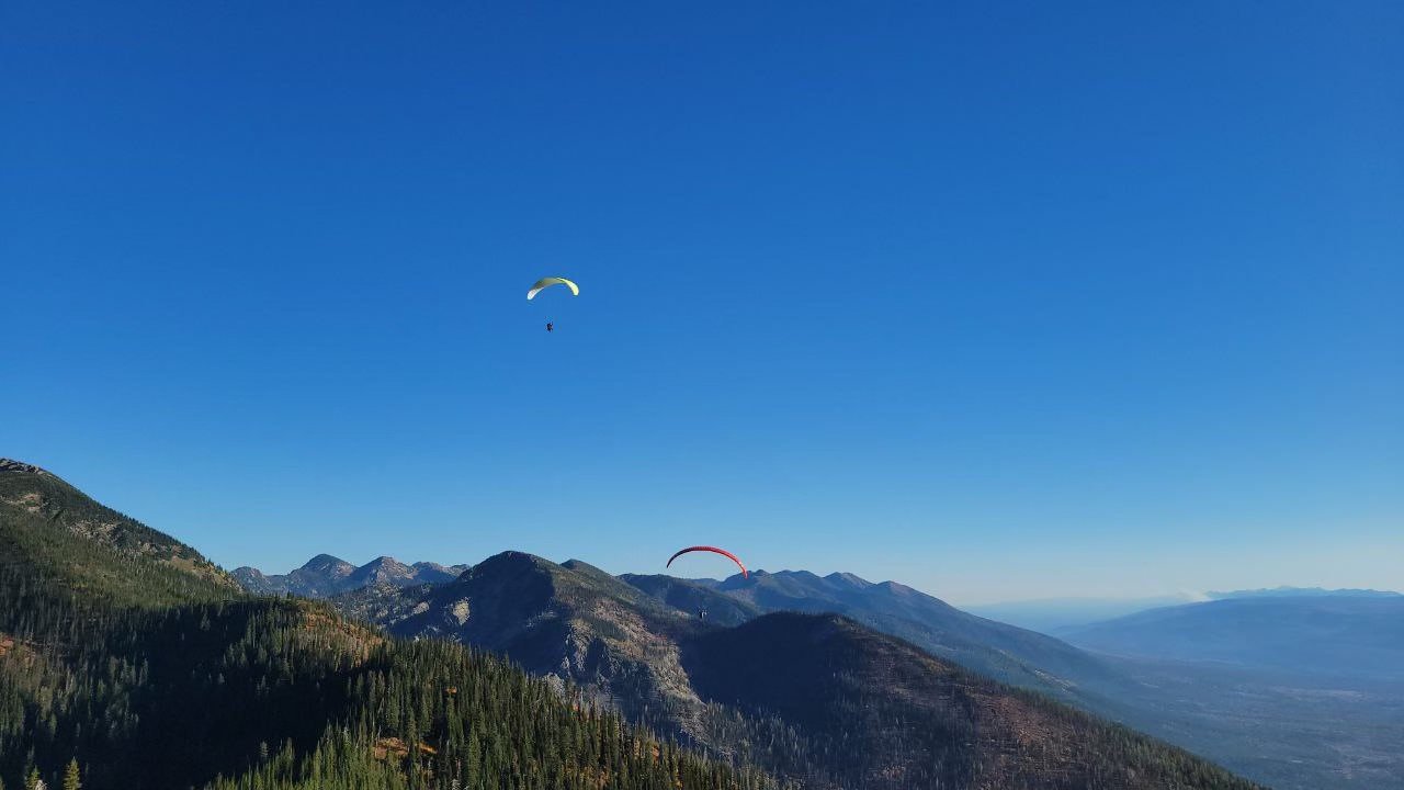
Checkerboard Launch, elevation 6,425 ft′, is nestled in the Swan Range in the Flathead Valley.. It is a southwest-facing site known for its fantastic morning flights, smooth evening glass-offs and incredible Cross Country. As a seasonal site, Checkerboard is the primary launch for USHPA certified pilots. Launch is accessible either on foot or by vehicle via Jewel Basin Road to Camp Misery.
Flying Our Site
The “Checkerboard” launch, near Mt. Aeneas, in the Flathead National Forest is the primary hang gliding and paragliding launch in the Flathead Valley. Hangglider pilots discovered and began launching Checkerboard launch in the late 1970s. The launch sits on a ridge overlooking the Flathead Valley and Flathead Lake.
Flying at the Checkerboard site is sensitive. In recent years increased use, and pilots landing on private property, has created issues with the local community. Please help us protect and maintain this site. Obey all FVSA bylaws.
The recent growth of freeflight in the Flathead Valley led to the formation of the FVSA in 2024. The FVSA is working to protect and expand freeflight in the Flathead Valley.
There are many different types of flying at our site. See Types of Flying by Clicking Here.
Things to Consider when Flying our site
Always maintain at least 200′ of clearance above Ground.
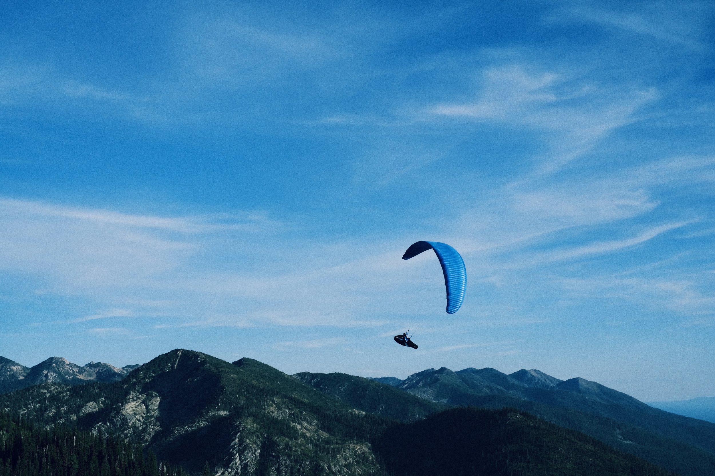
Expect active lift and sink mid-day. Climb rates and sink rates often exceed 400fpm. As such, novice (P2) pilots should not launch between 11am and 4pm.
Glide ratio to both main LZs is greater than 4:1. This means pilots should begin to head to the LZ if they are below launch height.
Pilots should avoid flying older, less performant gliders, especially those with higher porosity. There have been instances of pilots on older gear not being able to make it to an LZ.
Flying mid-day requires good thermaling skills. Knowing how to identify and turn in lift, how to use speedbar effectively, and how to time a launchable cycle are all important skills for a mid-day pilot.
Misreading the location of a thermal can have you accidentally turning in sink, quickly leaving you without enough altitude to make it to one of the LZs.
Unstable weather conditions can cause active air and strong headwinds, especially midday. Even experienced pilots on modern wings have landed short of the main LZs.
BEWARE SUMMER CONDITIONS. Caution should be taken when flying in June and August. The combination of hot, dense air aloft and uninsulated ground creates strong instability and high lapse rates. Thermals can be turbulent, and sharp edged.
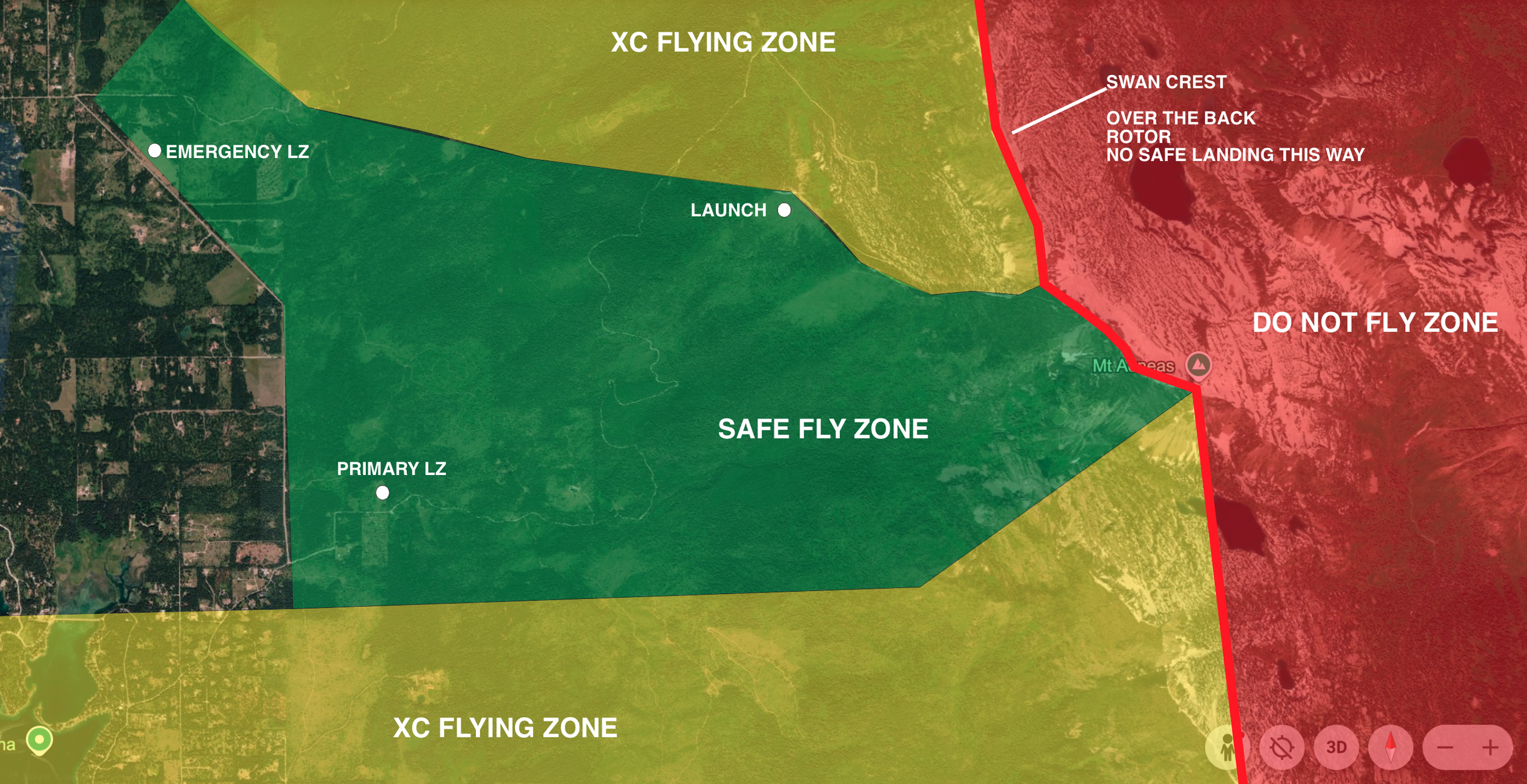
If winds aloft are strong, getting blown over the back is a significant danger. There are miles of trees and no fields directly behind the Swan Mountain Range. (See Image below)
Venturi and Rotor are concerned on the eastern shoulder and behind launch, in the compression at the summit, and over the back of launch and into the Noisy Basin. (See Map below)
Site Rules
All pilots must be current members of both USHPA & FVSA and must sign the FVSA waiver annually.
P3+/H3+ Pilots may fly independently.
P2/H2 Pilots must have 3 observed flights with P3+/H3+ FVSA Members or Site Observes
Absolutely no flying after dusk
No toplanding. The lee side of the launch is a very steep mountain face with thick trees. Rotor is usually present behind the launch ridge.
In recent years increased use, and pilots landing on private property, has created issues with the local community. Please help us protect and maintain this site
All first-time FVSA pilots need a site introduction from an experienced local pilot.
Pilots park and meet at Lunch Lady LZ Parking lot (known as “Lunch Lady”). Vehicle consolidation is recommended, as parking at Camp Misery is limited.
Be respectful of other recreationalists at Camp Misery.
DO NOT BLOCK THE ACCESS ROAD at Camp Misery. It needs to be kept clear for emergency vehicles to access.
Do not park on the side of Jewel Basin Road by the LZ.
Do not leave vehicles on the mountain overnight. Make sure to shuttle all vehicles down before or at sunset.
No tree trimming or tree removal is permitted.
Pilots should practice leave-no-trace.
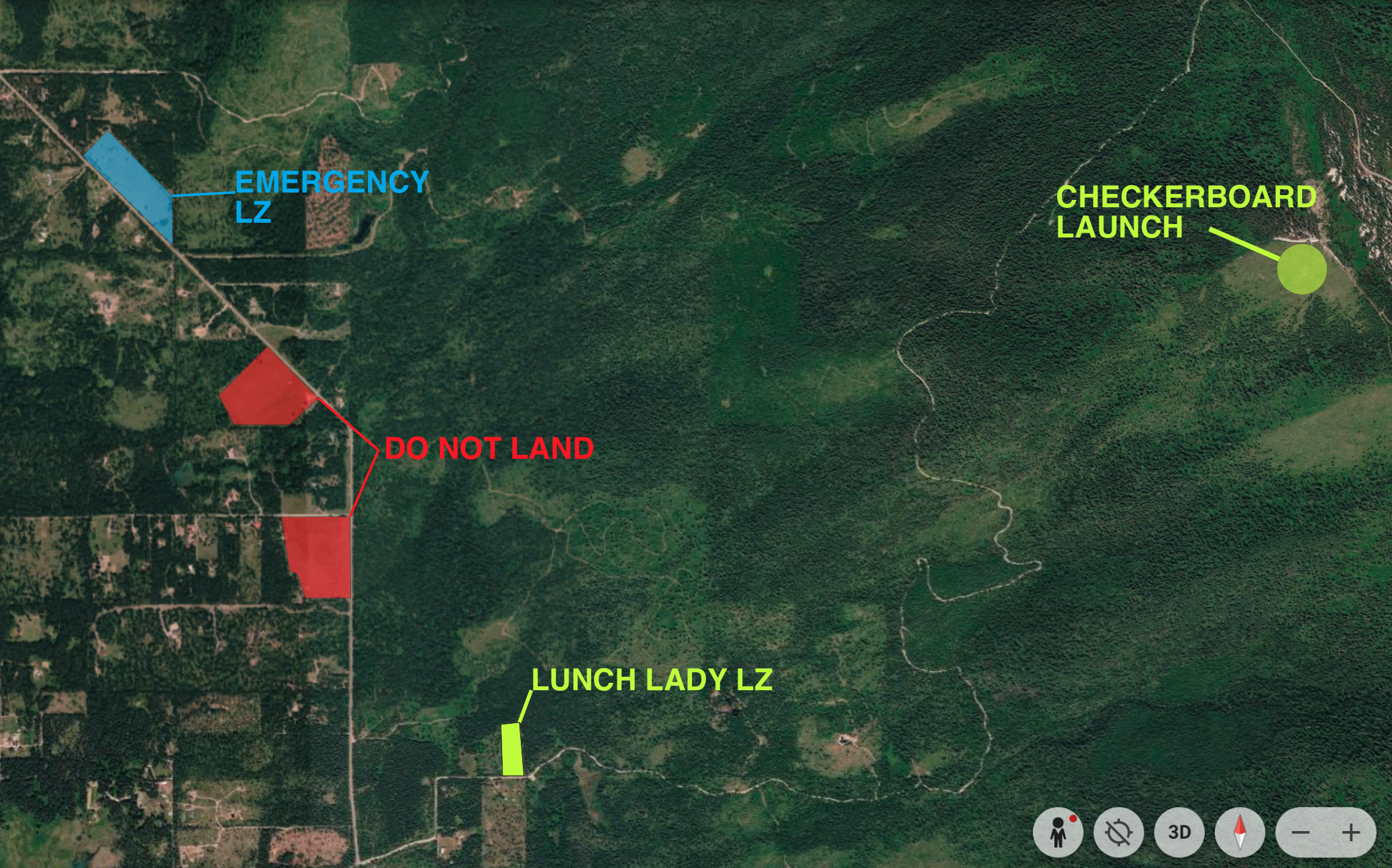
Primary LZ: Lunch Lady LZ
Maintained by: MT Department of Natural Resources and Conservation, Flathead Valley Soaring Association, The Stewart Family

Lunch Lady LZ is a large field with plenty of room for landing from a North or South Approach. A West or East approach is not only difficult but not recommended. A seasonal windsock is located in the field. Due to the specific hazards listed below, it is especially important that pilots walk this LZ prior to flying
Parking is available at the LZ in a small lot near the SE corner of the field. There is also an overflow parking lot at the junction of Foothill Rd. and Jewel Basin Rd. a half mile before the LZ.
Access the Landing zone from the Ladder in the Southeast Corner only! Do not open the gate due to livestock.
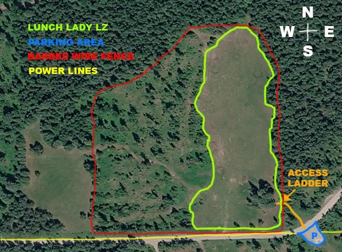
Lunch Lady Landing Zone Tips
Elevation: 3,094 ft
Glide from Launch: 4.9:1
The field is fully visible from launch, mid to late-summer if forest fires are in the area it may be difficult to recognize. Pilots should orient themselves to its location from launch prior to flying.
Landing Approach: Typical flying days mean a South or Southwest wind at the LZ. Pilots should anticipate landing as an active pilot due to the rotor potential below the treeline.
Hang glider pilots should have restricted landing field skills.
The LZ field is a known thermal trigger. Pilots should avoid forcing a landing when the LZ is releasing a thermal, typically mid- to late afternoon. In this situation, it is better to climb and/or maintain altitude until the thermal has completely released, then set up another approach.
Uneven surface and obstacles: There are rolling hills, burrows from animals, horses and livestock to watch out for. Pilots should avoid object fixation by focusing on clear space where they intend to go.
This LZ is technical and requires intermediate to advanced pilot skills with confidence in spot landings. This LZ is an elongated clearing and is surrounded by mature pine trees.
The most commonly used landing direction is setting up North and landing facing South on approach.
The most common landing pattern is to figure 8 over the trees on the North end of the field until a low enough altitude is reached to do a straight final glide into the field facing South
The LZ is not wide enough for an East or a West landing direction.
Powerlines and Fencing- We do have powerlines and barbed wire fencing on the South end of Lunch Lady LZ.
If the possibility of overshooting the landing zone from a North Approach, weight shift turn right towards the West in the last ⅓ of LZ to avoid powerlines and barbed wire fencing
While the LZ can easily be reached from launch on glide, it is important to monitor altitude and be cautious of getting too low in the bowl after launch.
DO NOT LAND IN ANY FIELD OTHER THAN THE DESIGNATED LZ. There have been issues in the past from pilots landing in privately owned fields. We MUST respect local land owners and their privacy. Our Emergency Landing Zone is only use for Emergencies!
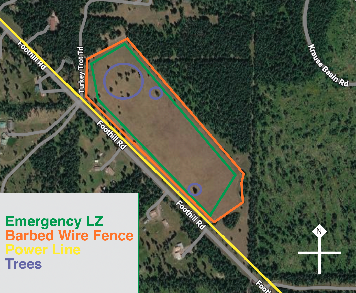
Emergency LZ
Owners: Flathead Valley Community College
Our Emergency Landing zone is located 1.5 miles Northwest of Lunch Lady LZ.. It is clearly visible from launch and it can glide easily from launch.This landing zone is not an alternative LZ and ONLY TO BE used for Emergency Landings.
Emergency Landing Zone Tips
Elevation: 3,185 ft
Glide from Launch: 5.8:1
Setup in Southeast or NorthWest end of landing zone
Tall trees, powerlines, and roadways bound all but the South side of the field. Pilots must set up their landing approach and lose altitude above the clear space to the Northwest or Southeast.
Profanity, smoking, or other activities inappropriate.
A windsock is not maintained at this field.
Do not park alongside Foothills Road or Private Property.
This LZ is Private Property and should ONLY be used for Emergency Landings when Ground level winds are either East or West.
FVSA does not recommend pilots utilizing this landing zone, rather make better decisions with the forecast and be selective of the flying conditions.
Leave Property Immediately after landing
Do not pack equipment in field
FVSA takes no responsibility to the pilot's decision making or consequences following landing at the Emergency Landing zone or any private property,